by Alastair Bland
August 2, 2017
Originally published by Hakai Magazine
Meteorologists had never seen anything quite like it—a mass of abnormally warm surface water that overwhelmed much of the northeastern Pacific Ocean for three years starting in late 2013. They called it the Blob.
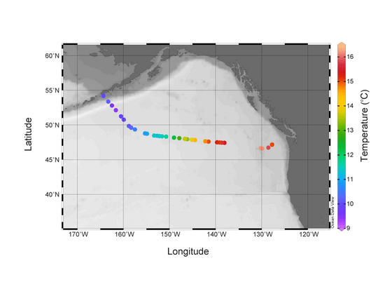
Locations where surface seawater samples were collected for the InFORM project in July 2015. Surface seawater temperatures at the time of collection are shown with values greater than 16C in the anomalous region referred to colloquially as “the blob”.
The purpose of this short post is to update readers on the activities of the Integrated Fukushima Ocean Radionuclide Monitoring (InFORM) project. This post is the most recent in a series documenting scientific research into the impact of the Fukushima Dai-ichi disaster on environmental and public health. Surface seawater samples were collected from the icebreaker CCGS Sir Wilfrid Laurier as it traveled between Victoria BC to Dutch Harbor Alaska during July 2015. These seawater samples will be analyzed to characterize the distribution of Fukushima derived radionuclides 137-Cesium (137Cs half life ~30 years), and 134-Cesium (134Cs half life ~2 years). As in previous years this information will help to determine how well model predictions of the activities and progression of ocean borne contamination across the Pacific Ocean match with observations. Understanding the spread of this contamination provides important information on the impact of the Fukushima Dai-ichi disaster on the health of the Pacific ecosystem and the North American public. The evolution of the contaminant plume in time and space also helps the scientific community to better understand ocean mixing which is a key parameter toward understanding the oceans role in mitigating atmospheric greenhouse gas increases and climate change. Continue reading Update: Sampling for Fukushima Derived Radionuclides in the Northeast Pacific and Arctic 2015→
Bow of the CCGS Laurier. Great ship and crew for science operations in the Arctic.
The purpose of this short post is to update readers on the activities of the Integrated Fukushima Ocean Radionuclide Monitoring (InFORM) project. This post is the most recent in a series documenting scientific research into the impact of the Fukushima Dai-ichi disaster on environmental and public health. Today the icebreaker CCGS Sir Wilfrid Laurier will leave Victoria BC bound for Dutch Harbor Alaska and then up through Bering Sea and Strait to the Arctic Ocean. On the way the InFORM project will collect surface seawater to characterize the distribution of Fukushima derived radionuclides 137-Cesium (137Cs half life ~30 years), and 134-Cesium (134Cs half life ~2 years). As in previous years this information will help to determine how well model predictions of the activities and progression of ocean borne contamination across the Pacific Ocean match with observations. This provides important information on the impact of this contamination on the health of the Pacific ecosystem and the North American public that rely on the ocean for their food, livelihood and recreation. The evolution of the contaminant plume in time and space also helps the scientific community to better understand ocean mixing which is a key parameter toward understanding the oceans role in mitigating atmospheric greenhouse gas increases and climate change. Continue reading Sampling for Fukushima Derived Radionuclides in the Northeast Pacific and Arctic 2015→
Satellite measurements of ocean temperature (illustrated by color) and the direction of currents (white arrows) help show where radionuclides from Fukushima are transported. Large scale currents transport water westward across the Pacific. Circles indicate the locations where water samples were collected. White circles indicate that no cesium-134 was detected. Blue circles indicate locations were low levels of cesium-134 were detected. Small amounts of cesium-134 have been detected in a water sample taken Feb. 19, 2015, from a dock in Ucluelet, British Columbia. (Woods Hole Oceanographic Institution)
As radiation from the Fukushima nuclear power-plant disaster drifted across the Pacific, fears that salmon and other marine life could be contaminated spread along the British Columbia coast.


