Tag Archives: Environmental Monitoring

May 2015 InFORMal Monitoring Update

May2015 w Labels-01
InFORMal monitoring results from samples collected in March 2015

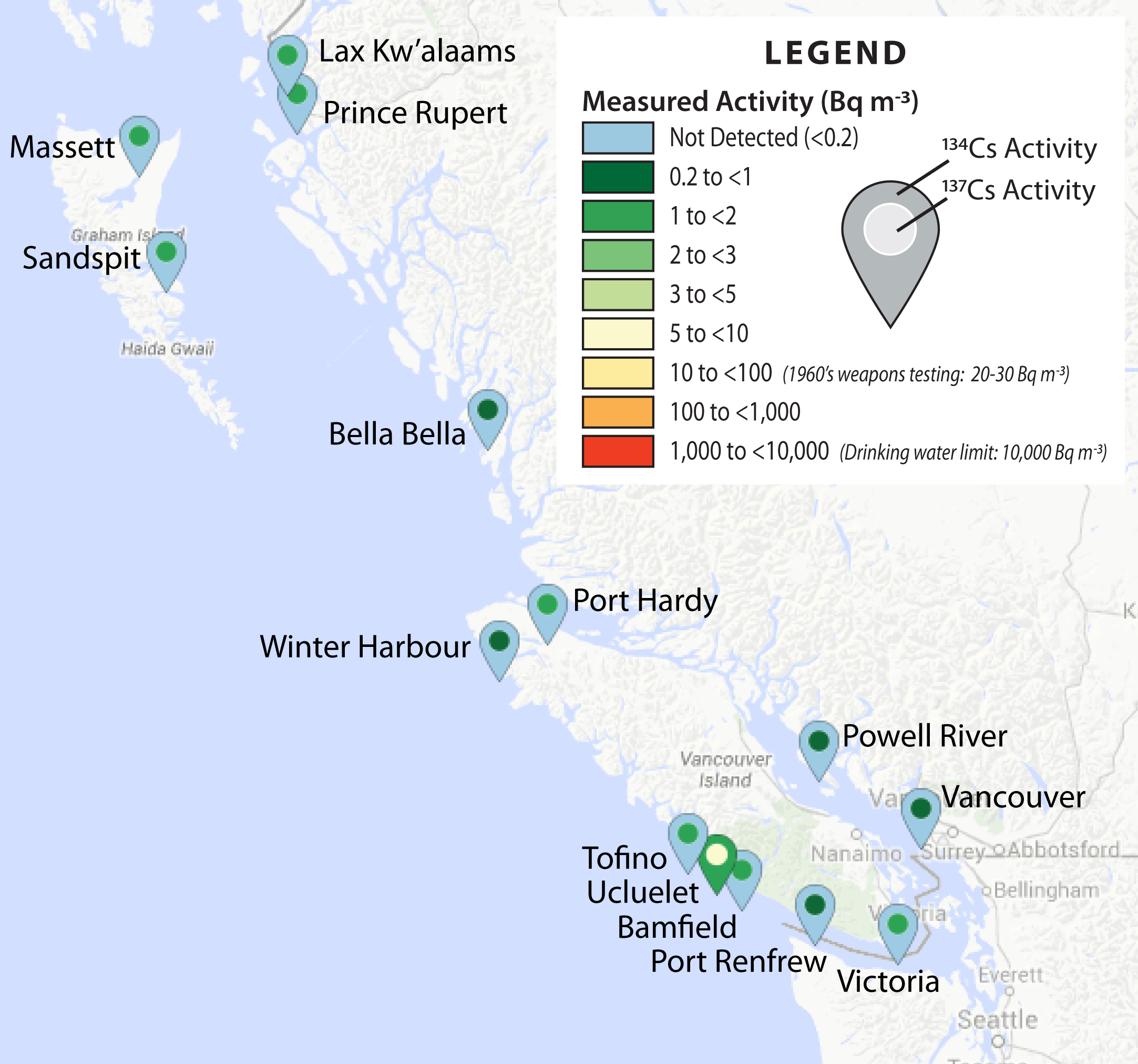
Results* from March are now available from 10/12 of the current InFORM sampling locations. Recent samples from Sandspit and Bella Bella are still being processed and data shown are from February. After the positive measurement of Fukushima-derived 134Cs radiation in February at Ucluelet, we expected this signal to spread in samples collected in March. Instead, there is no detectable 134Cs (detection limit ~0.2 Bq m-3) in any of the March samples. Continue reading May 2015 InFORMal Monitoring Update

Analysis of Beached Grey Whale in British Columbia for Fukushima Radioisotopes

By Jay T. Cullen

Grey Whale being dissected on Wickaninnish Beach April 23, 2015 (The Whale Centre)

The purpose of this post is to report analyses carried out by the InFORM project on muscle and blubber samples from a grey whale (Eschrichtius robustus), that beached near Tofino, BC on April 20, 2015. The post is the most recent in a series that aims to communicate results of scientific research into the impact of the Fukushima disaster on the environment. With the cooperation of the Ucluelet Aquarium the InFORM project was able to obtain samples of the whales muscle and blubber which were analyzed for the presence of gamma emitting radioisotopes in Health Canada’s laboratories in Ottawa, ON Canada. The gamma radiation spectra were dominated by naturally occurring radioisotopes, primarily Potassium-40 (40K half life 1.25 billion years), and after 24 hours of counting no Fukushima derived Cesium-134 (134Cs half life ~ 2 years), a fingerprint of the disaster in the environment could be detected. The unfortunate demise of the grey whale is very unlikely to have been the result of acute or chronic radiation exposure owing to Fukushima derived radionuclides in seawater and the whales food. Continue reading Analysis of Beached Grey Whale in British Columbia for Fukushima Radioisotopes

How Much Radioactivity Are We Exposed to While Sampling Seawater for Fukushima Radioisotopes?

By Jay T. Cullen

The purpose of this post is to introduce a brief, informal movie made while using a Geiger Counter in the laboratory today. This diary is part of an ongoing effort to communicate what the scientific community is learning about the impact of the Fukushima disaster on environmental and public health. A Geiger Counter was used to examine ionizing radiation counts per minute in the laboratory owing to background radioactivity, the concentrated natural and man made isotopes in 20 liters of seawater collected by InFORM citizen scientist volunteers, the uranium oxide glaze on a Fiestaware dinner platter and Uraninite ore mined from New Hampshire. This simple demonstration supports more sensitive measurements indicating our citizen scientists are exposed to no more ionizing radiation than is typical of background when collecting seawater samples.

Continue reading How Much Radioactivity Are We Exposed to While Sampling Seawater for Fukushima Radioisotopes?

April 2015 InFORMal Monitoring Update

April2015 w Labels
InFORMal monitoring results from samples collected in February and March 2015

Results* from early February and March are now available from 10/13 of the InFORM sampling locations. Recent samples from Bamfield, Vancouver, and Powell River are still being processed. To date, no InFORM coastal samples have detectable (detection limit ~0.2 Bq m-3) levels of 134Cs, the radionuclide that is the fingerprint of Fukushima derived radiation due to its short half life (~2 years). An interesting note is that the February Tofino sample was collected on the 7th, just 12 days before the ORO sample collected in Ucluelet that was the first to contain measureable 134Cs. Continue reading April 2015 InFORMal Monitoring Update

A Quick Look at a Tide Pool at Botanical Beach Near Port Renfrew BC

This is a short video made on April 4, 2015 at Botanical Beach near Port Renfrew BC, one of our citizen scientist sampling locations organized by Surfrider Vancouver Island. Botanical Beach is at the north end of the Juan de Fuca Provincial Park on the southwest shore of Vancouver Island.

We arrived on the rising tide when the larger, more impressive tide pools were already submerged but this little pool shows the main types of organisms one can find there.  Almost got our feet wet in the end.