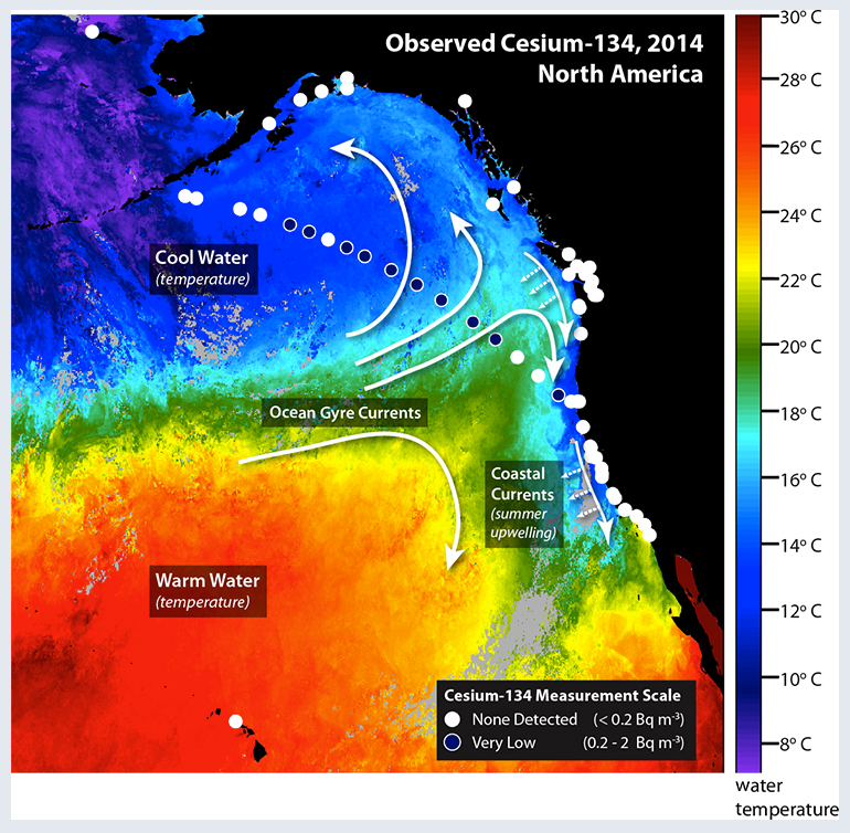
Satellite measurements of ocean temperature (illustrated by color) and the direction of currents (white arrows) help show where radionuclides from Fukushima are transported. Large scale currents transport water westward across the Pacific. Circles indicate the locations where water samples were collected. White circles indicate that no cesium-134 was detected. Blue circles indicate locations were low levels of cesium-134 were detected. Small amounts of cesium-134 have been detected in a water sample taken Feb. 19, 2015, from a dock in Ucluelet, British Columbia. (Woods Hole Oceanographic Institution)
This short blog summarizes an open access paper published today reporting results from a Canadian monitoring program tasked with documenting the arrival of ocean borne Fukushima contamination along the North American Pacific coast. This diary is part of an ongoing effort to communicate the best science available on the impacts of the Fukushima Dai-ichi meltdowns on the environment. High quality measurements to look for Fukushima derived radiocesium were made in seawater in the North Pacific and Arctic Oceans from 2011 to early 2014. The authors concluded that:
Fukushima derived radiocesium was first detected 1500 km west of British Columbia Canada in June 2012
Contamination was detected on the continental shelf (near coastal waters) in June 2013
By February 2014 Fukushima radiocesium was present at levels similar to preexisting weapons testing derived 137-Cs
These same models predict that total radiocesium levels from weapons testing fallout and Fukushima will likely reach maximum values of ~3-5 Becquerel per cubic meter (Bq m-3 of seawater in 2015-2016 and then decline to fallout background level of ~1 Bq m-3 by 2021
Fukushima will increase northeastern Pacific water to levels last seen in the 1980’s but does not represent a threat to environmental or human health
Satellite measurements of ocean temperature (illustrated by color) from July 28th to August 4th and the direction of currents (white arrows) help show where radionuclides from Fukushima are transported. Large scale currents transport water westward across the Pacific. Upwelling along the west coast of North America in the summertime brings cold deep water to the surface and transports water offshore. Circles indicate the locations where water samples were collected. White circles indicate that no cesium-134 was detected. Blue circles indicate locations were low levels of cesium-134 were detected. No cesium-134 has yet been detected along the coast, but low levels have been detected offshore. (Woods Hole Oceanographic Institution)
The purpose of this post is to report on new results coming out the crowd-funded Our Radioactive Ocean program headed up by Dr. Ken Buesseler of Woods Hole Oceanographic Institution. This post is part of an ongoing series dedicated to scientific inquiry into the impact of the triple meltdowns at Fukushima on the health of the North Pacific Ocean and residents of the west coast of North America. Measurements of the cesium radioisotopes 134-Cs (half life ~ 2 years) and 137-Cs (half life ~30 years) were made on samples collected on a transect between Monterey Bay CA and Dutch Harbor AK this summer. Because of its relatively short half life 14-Cs serves as an unequivocal tracer of Fukushima contamination in the environment. Fukushima derived 134-Cs was detected at offshore stations with a maximum activity of ~ 2 Bq/m^3 and total 137-Cs activities of ~7 Bq/m^3 of seawater. Measurements have yet to detect 134-Cs in nearshore waters sampled up and down the North American west coast. These activities of Cs are orders of magnitude below levels thought to pose a measurable risk to human health or marine life, according to international health agencies.
For a primer on radioactivity in the ocean and the units used to discuss radioactive elements in the environment please visit this post.
A press release from WHOI regarding these new results can be found here and details about sampling locations and activities of Cs detected are available here.
At a great majority of sites sampled along the coast and offshore the activity of 134-Cs is below detection limit (~legacy contamination resulting from atmospheric weapons testing in the 20th century. Similar to previous work by Dr. John Smith of the Department of Fisheries and Oceans Canada the presence of the contaminated plume of seawater owing to releases from Fukushima can be detected in offshore stations (150 – 1500 km) with levels of 134-Cs approaching 2 Bq/m^3 and total 137-Cs (bomb + Fukushima) of about ~7 Bq/m^3. These levels of 137-Cs are similar to levels in the North Pacific Ocean that were present in 1990 owing to the combined effects of Chernobyl and weapons testing fallout as shown in the figure below.
Activity of 137-Cs in the North Pacific after Povinec and others (2013) http://www.biogeosciences.net/10/5481/2013/bg-10-5481-2013.html with arrows indicating the impact of Chernobyl, 2008 137-Cs activity in the Irish Sea and 2014 levels offshore of western North America post Fukushima for comparison.
Activities of these isotopes were about 10 million fold higher in coastal waters near the Fukushima Dai-ichi nuclear power plant off Japan in the weeks following the beginning of the disaster in March and April 2011 when rates of release and seawater concentrations were at their peak. Current releases from the plant support seawater activities on the order of 10’s-100’s of Bq/m^3 within 2 km of the plant site. The highest activities associated with the most contaminated seawater from Fukushima are predicted to travel across the North Pacific with prevailing currents and arrive in North American waters between this year and next. These offshore activities of Fukushima derived 137-Cs of ~ 5 Bq/m^3 exceed predicted activities of ~3 Bq/m^3 suggesting that offshore activities are likely reaching near peak values. The measurements being made by the international scientific community will undoubtedly help to improve our understanding of mixing and transport in the oceans.
The activities of radiocesium being detected offshore are well below levels thought to represent significant radiological health risks to marine organisms or residents of the west coast of North America. To this point no 134-Cs from the contaminated plume approaching the coast has been detected in nearshore waters. Ongoing monitoring by programs like Our Radioactive Ocean and its partner program InFORM which are making measurements of contamination in seawater and marine organisms will be key to understanding impacts of the Fukushima on our environment.
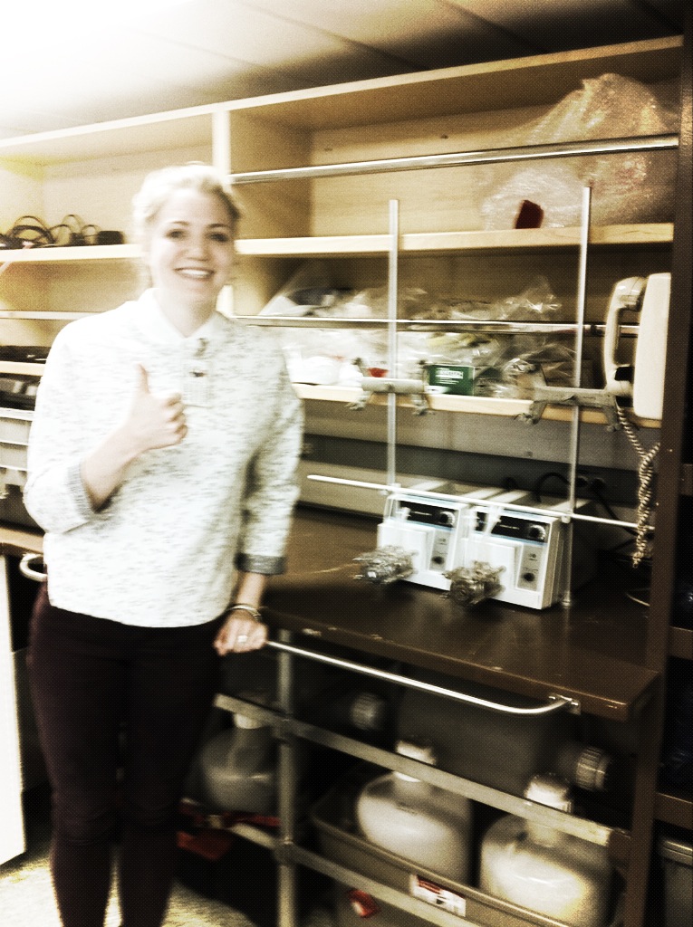
In addition to the citizen scientist sampling network that is under construction the other pillar of the InFORM project is the collection of samples in the open North Pacific and Arctic Oceans. The first samples for radionuclide analyses were collected by University of Victoria undergraduate student Kathryn Purdon on the first leg of the icebreaker CCGS Sir Wilfrid Laurier’s annual operations in Canada’s far North.
UVic Undergraduate Student Research Award recipient Kathryn Purdon setting up radionuclide sampling equipment on CCGS Sir Wilfrid Laurier
The goal of our sampling program was to obtain a detailed information about the location and intensity of the Fukushima contaminated plume of seawater by collecting seawater across the northeast Pacific from Victoria to Dutch Harbor, Alaska and up through the Bering Strait in the Chukchi Sea in the Arctic Ocean.
Surface water samples collected for radionuclide analysis July 5-22, 2014 on CCGS Sir Wilfrid Laurier.
60 litres of seawater was collected for each sample and processed to concentrate radioactive elements for subsequent detection by gamma spectometry.
CCGS Sir Wilfrid Laurier at dock CCG base Victoria, BC.


