
Oceanic monitoring:
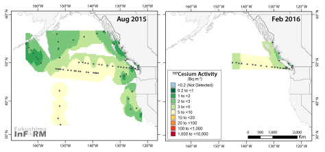
The peak concentrations of the Fukushima plume are now nearing North American coastal waters according to the data collected in February 2016 along Line P. The highest concentrations are no longer measured at Station Papa, as they have been since it was first detected in June 2013. Rather, measured activities at Station Papa are now indicating the back side of the highest concentrations. Peak sea surface concentrations, the total of Fukushima radiation and remains from nuclear weapons testing, measured 8.3 Becquerels per cubic meter (Bq m-3) at station P8. This concentration is over 1,000 times lower than the 10,000 Bq m-3 level of concern according to Health Canada. Station P8, located ~200 km west of Tofino or nearly 300 km from the mouth of the Strait of Juan de Fuca remains well off the continental shelf and we know from coastal samples collected at the end of 2016, discussed below, that this peak signal has not yet progressed to the coast.

The progression of the plume along Line P monitoring stations is the subject of a recently submitted manuscript by InFORM scientist, Dr. John Smith. He finds that the plume crossed the Pacific from Japan moving at about the speed of a determined tortoise (5-7 km per day). However, once it reached the disorganized flows of the North Pacific Bifurcation it slowed to a rate more approximate of a garden snail or half the speed of a sun star (~0.8 km per day). The result is that the British Columbia and Washington coasts are perhaps buffered from the core of the Fukushima plume by coastal processes, like upwelling/downwelling.
Continued monitoring of offshore and coastal waters will help oceanographers tease out what portion of the core plume waters penetrates into the coastal environment versus being directed into the strong offshore Alaskan and Californian currents for continued dispersion.
Coastal Monitoring:
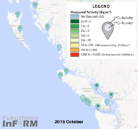
The coastal average concentration of cesium-137 is now at 2.7 Bq per m3 according to data from samples collected in October through December 2016 which are now available. The highest concentrations were sampled from Winter Harbour in December which, at 4 Bq per m3 is our second highest measured activity to date, after the initial detection back in February 2015. The lowest values continue to be from sites within the Strait of Georgia, at 1.7 Bq per m3.
Taking a closer look at the data recently, I noticed that the samples from the North Coast and Haida Gwaii didn’t respond quite respond in the same way throughout the timeseries. While I previously had lumped these data together, they are now separated since they may each tell part of the story of their local circulation.
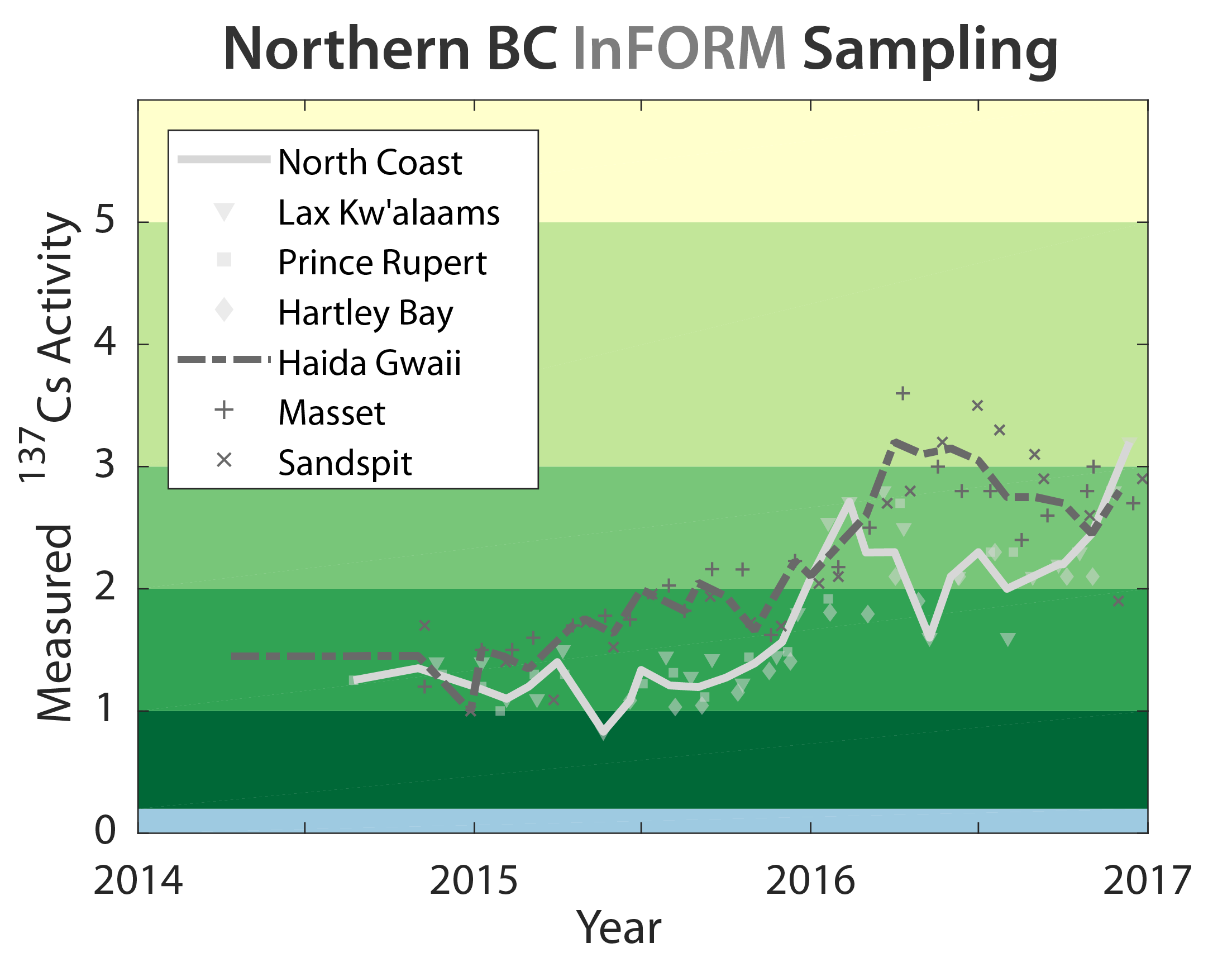
Over two years of monitoring, a pattern is developing where the 137Cs activities measured from Haida Gwaii and the North Coast only closely resemble each other during the winter months. During the summer months, however, samples from Haida Gwaii are considerably higher than their nearby North Coast communities. Interestingly, measurements from Sandspit are more consistent with those from Masset even though one might think they should more closely reflect Hartley Bay. To understand this signal, we need a better understanding of circulation in northern BC.
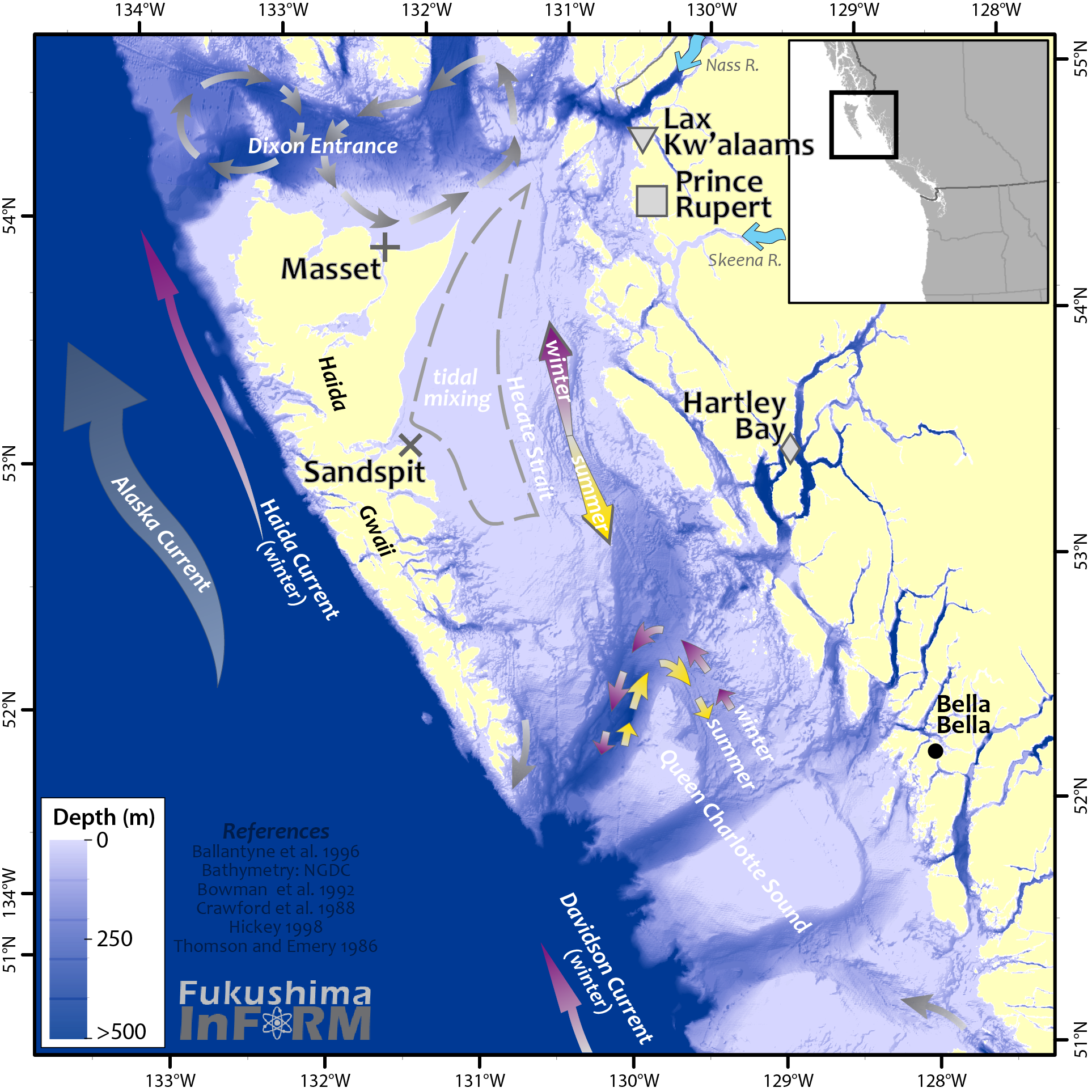
Oceanic waters are transported to the north coast generally along the Alaska Current. On average, the bifurcation of the North Pacific Current into the Alaska Current and California Current occurs around the Washington-Oregon border, though it is possible for the bifurcation to occur as far north as the Alaska-BC border. As the waters travel northward along the Alaska Current, and the coastal currents that are more closely hugging the shore, they branch off into the various inlets at the Strait of Juan de Fuca, Queen Charlotte Sound, Dixon Entrance, and so on.
If we are tracing the path of water using the Fukushima radiation as a dye, we know the core of the Fukushima plume remains offshore thanks to our oceanic monitoring. The more direct the path is to onshore, the higher the 137Cs concentrations should be in our coastal samples. The more mixing along that path, the lower the concentrations. So we may assume that in Northern BC, the waters entering through Dixon Entrance travelled a more direct path from the plume based on the higher measured activities at Masset compared to those at Winter Harbour or Bella Bella.
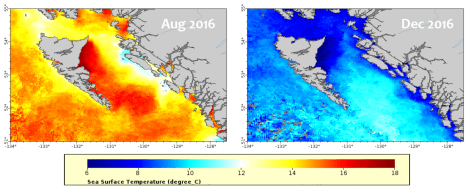
After the water transited the permanent eddies of Dixon Entrance it joins with the waters of Hecate Strait. Hecate Strait is a wide (50 – 150 km, 30 – 90 mi) basin with a glacially carved trough (300 – 100 m deep shoaling northward) on the eastern side and a broad shallow (<50 m deep) shelf on the western side. This geometry means that most of the flow in Hecate Strait is confined to the east where the waters may move more freely than on the constricted shelf. Due to the seasonally reversing prevailing winds in this part of the world, the flow through Hecate Strait also reverses. In the summer, winds push the water south along the coast. While in winter, the flow is northward through the trough. At the southern entrance of Hecate Strait, the circulation swirls around a seafloor, or bathymetric, feature called Middle Bank. The direction of the swirl changes depending on the season, but this motion does not have a known net total transport into, or out of, Hecate Strait.
While the flow in eastern Strait is rather well understood, there is little published about the average flows on the shallow, tidally-mixed shelf on the western side of the bank. Currents and winds do a good job of mixing these waters such that they are consistently exchanging heat and gases with the atmosphere. However, the lack of published information about flows makes it somewhat challenging to understand the connection between the waters of Sandspit and Masset.
To tease out this connection, and the differences between Haida Gwaii and the rest of the North Coast stations (Lax Kw’alaams, Prince Rupert, Hartley Bay), we will be further investigating two hypotheses. In no particular order, the first hypothesis would futher investigate the circulation of Haida Gwaii to determine if the marine connection between the Haida Gwaii communities somehow bypasses the majority flows of eastern Hecate Strait. This would suggest that the Fukushima signal is closely related to the reversing wind driven circulation in Hecate Strait. The second hypothesis would look at the roll of salinity in this coastal story. The two major rivers in this area are the Nass and Skeena. Being freshwater, they should have no cesium present. Could the observed signal be explained by communities of the North Coast having a strong riverine influence during the summer freshet that results from snowmelt?

We previously examined the relationship between salinity and cesium earlier in the project, but we have much more data now after 2.5 years of sampling and will be examining it again to determine which of these proposed hypotheses is more likely. Check back next time to see what we find out!

One thought on “June 2017 InFORMal Update”