Powell River, BC
November sampling was carried out in close proximity to the Kelly Creek Community School on the Sunshine Coast. Powell River is found on the traditional territory of the Tla’amin First Nation.

Location of Powell River, BC

Powell River, BC
November sampling was carried out in close proximity to the Kelly Creek Community School on the Sunshine Coast. Powell River is found on the traditional territory of the Tla’amin First Nation.
Location of Powell River, BC
Masset Haida Gwaii, BC
InFORM volunteer Kurt headed out to the beach shortly after Haida Gwaii had experienced ~120 kph winds from a significant fall/winter storm. Haida Gwaii is ~450 miles north of Vancouver and 80 miles west of Prince Rupert and are the most westerly islands in Canada. They have been home for the Haida First Nation for at least 8000 years. This sample was collected near the village of Masset on the north coast of Haida Gwaii.
On the beach with the InFORM sampling kit

Location of Masset and sample collection
Port Renfrew, BC
November 2014 sampling for the InFORM projects was carried out by volunteers from our NGO partner Surfrider Foundation Vancouver Island. If you love the ocean you will love Surfrider. Port Renfrew is located on the southwest coast of Vancouver Island. Port Renfrew is in the traditional territory of the Pacheedaht (meaning “people of the sea foam”) First Nation. Port Renfrew is the southern terminus of the West Coast Trail and is close to some of the biggest trees in Canada and in the world.
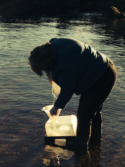
The picture below shows the first InFORM sample in Port Renfrew being collected in November 2014.
Location of Port Renfrew, BC
Winter Harbour, BC
The following description was taken from the Cape Scott – Winter Harbour Cottages website which can be found here.
Winter Harbour BC is on the northwest coast of Vancouver Island, 75 kilometres (gravel road) west of Port Hardy. Approximately a 5 hour drive from Campbell River. Winter Harbour is also accessible by water, via Quatsino Sound, from Coal Harbour or Port Alice.
In the 1930’s Winter Harbour was settled as a remote fishing community for west coast trollers. Having survived the ups and downs of the commercial fishing fleet, the village has evolved into a popular sports fishing destination. Fifteen minutes by speed boat puts fishers onto productive ocean fishing grounds. Salmon and bottom fish abound offshore as well as in the sheltered waters of Quatsino Sound.Winter Harbour is close to many wild, west coast beaches and hiking trails. Within the village, an historic boardwalk leads through the forest and along the shore. Nearby, Botel Park offers a rainforest hike from the community to an outside shore.
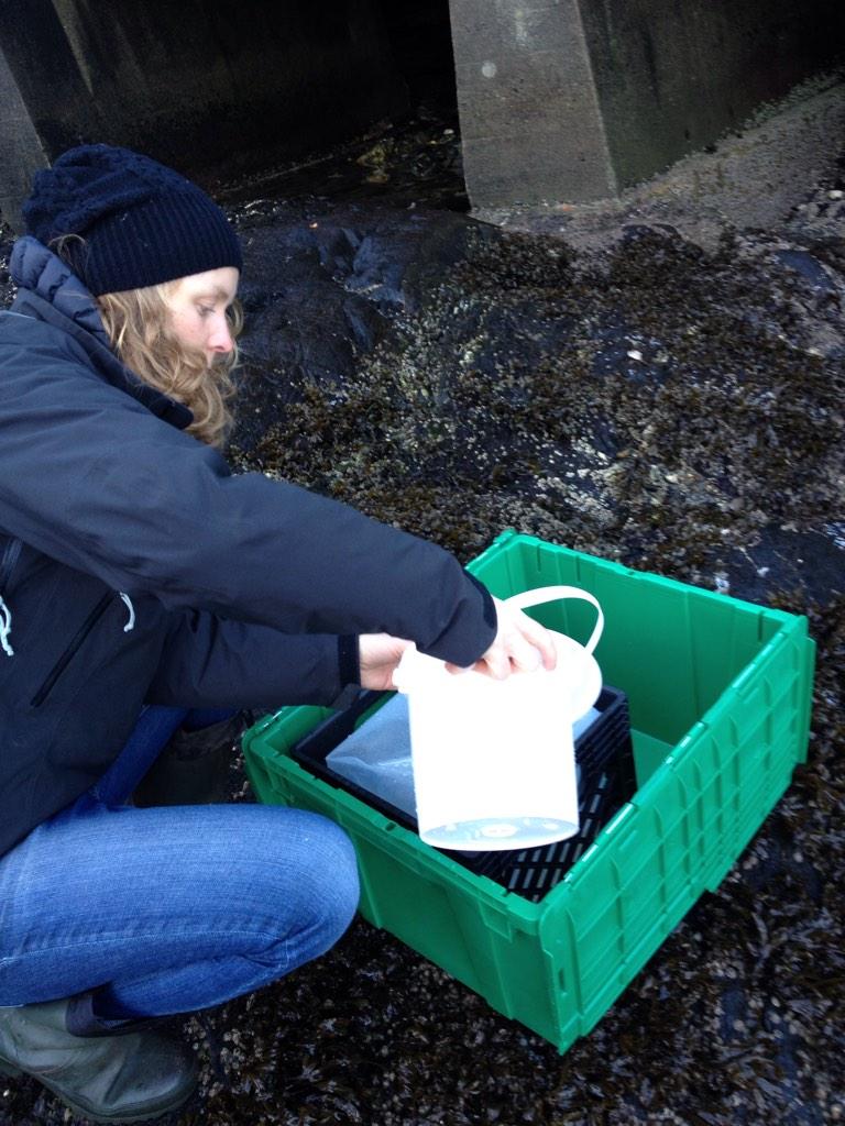
Here is a picture of the InFORM sampling kit on the dock in Winter Harbour ready to be filled with seawater and returned to UVic for processing and later analysis. Results will be reported as they become available.

Winter Harbour’s location is indicated on the map below and more information about the settlement can be found here>
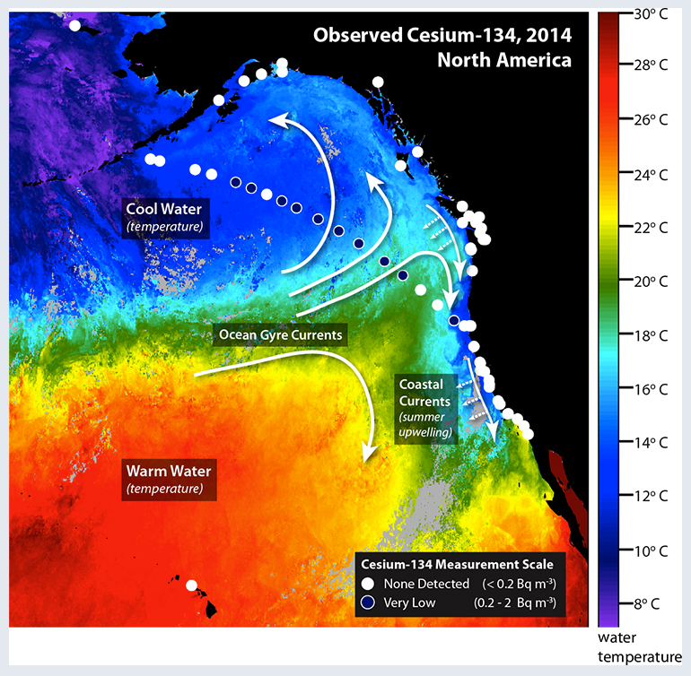
The purpose of this post is to report on new results coming out the crowd-funded Our Radioactive Ocean program headed up by Dr. Ken Buesseler of Woods Hole Oceanographic Institution. This post is part of an ongoing series dedicated to scientific inquiry into the impact of the triple meltdowns at Fukushima on the health of the North Pacific Ocean and residents of the west coast of North America. Measurements of the cesium radioisotopes 134-Cs (half life ~ 2 years) and 137-Cs (half life ~30 years) were made on samples collected on a transect between Monterey Bay CA and Dutch Harbor AK this summer. Because of its relatively short half life 14-Cs serves as an unequivocal tracer of Fukushima contamination in the environment. Fukushima derived 134-Cs was detected at offshore stations with a maximum activity of ~ 2 Bq/m^3 and total 137-Cs activities of ~7 Bq/m^3 of seawater. Measurements have yet to detect 134-Cs in nearshore waters sampled up and down the North American west coast. These activities of Cs are orders of magnitude below levels thought to pose a measurable risk to human health or marine life, according to international health agencies.
For a primer on radioactivity in the ocean and the units used to discuss radioactive elements in the environment please visit this post.
A press release from WHOI regarding these new results can be found here and details about sampling locations and activities of Cs detected are available here.
At a great majority of sites sampled along the coast and offshore the activity of 134-Cs is below detection limit (~legacy contamination resulting from atmospheric weapons testing in the 20th century. Similar to previous work by Dr. John Smith of the Department of Fisheries and Oceans Canada the presence of the contaminated plume of seawater owing to releases from Fukushima can be detected in offshore stations (150 – 1500 km) with levels of 134-Cs approaching 2 Bq/m^3 and total 137-Cs (bomb + Fukushima) of about ~7 Bq/m^3. These levels of 137-Cs are similar to levels in the North Pacific Ocean that were present in 1990 owing to the combined effects of Chernobyl and weapons testing fallout as shown in the figure below.

The activities of radiocesium being detected offshore are well below levels thought to represent significant radiological health risks to marine organisms or residents of the west coast of North America. To this point no 134-Cs from the contaminated plume approaching the coast has been detected in nearshore waters. Ongoing monitoring by programs like Our Radioactive Ocean and its partner program InFORM which are making measurements of contamination in seawater and marine organisms will be key to understanding impacts of the Fukushima on our environment.
